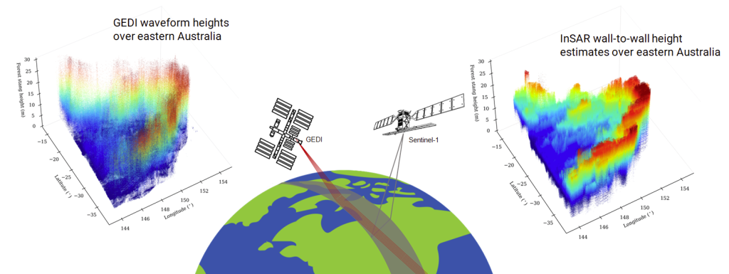
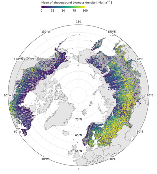
• Skip to primary navigation
  • Skip to main content
NASA MAAP

NASA MAAP

Multimission Algorithm and Analytics Platform

  • About MAAP
  • News
  • Explore
    • MAAP Zenodo (Publications)
    • sciX Publication Search
    • Science
    • Events
  • Communities
    • GitHub Discussions
    • ESA MAAP Home
  • Help
    • Documentation (ReadTheDocs)
    • Terms of Service
    • Open Policies
    • Bug/Feature Reports (GitHub)
  • Login
    • Profile
  • Show Search
Hide Search

News

MAAP version 4.0.0 Release

July 7, 2024

MAAP v4.0.0 has been released. It is a major new release with some breaking changes. Some highlights include:

  • The “Basic Stable” workspace stack has been renamed to “Python (default)”. The associated default “vanilla” conda environment has been renamed to “python”.
  • JupyterLab has been updated to v4.
  • Added all packages from the previous vanilla workspace (now called python) to the R workspace.

Please see the GitHub Announcement for the full details.

GitHub Announcement: https://github.com/orgs/MAAP-Project/discussions/1028

Large-Scale Canopy Height Mapping Using C-band InSAR Coherence and GEDI LiDAR Data

December 19, 2023

Cartoon indicating the combination of GEDI and InSAR data

Dry forests and savannas have highly heterogeneous horizontal and vertical structure of woody vegetation and high temporal variability in moisture and phenology. This presents distinct challenges to SAR-based approaches to mapping canopy-height compared to tropical and temperate forests. Dense time-series of C-band (Sentinel-1A/1B) and, in future, L-band (NASA/ISRO NISAR) provide a pathway to reduce the impact of signal-noise and environmental conditions and to extract additional information more directly related to height, using repeat-pass Interferometric SAR (InSAR) techniques.  This work explores the potential information in Sentinel-1(S1) C-band InSAR temporal decorrelation and Global Ecosystem Dynamics Investigation (GEDI)-derived relative height metrics for canopy height estimation. The 12-day InSAR correlation (𝛾) and seasonal median were analyzed over a wide range of canopy heights and woody ecosystems, with a focus on dry forests and savannas in Australia, India, and South Africa as part of a NASA Carbon Monitoring System (CMS) investigation. To scale up the geographical extent, the algorithm was deployed on NASA’s Multi-Mission Algorithm and Analysis Platform (MAAP). To further enhance the computational efficiency, a tile-based approach is employed using the Military Grid Reference System. The canopy height maps were produced for  ~12.3 million km2  by processing nearly 1500 10x10 Sentinel-1 C-band Coherence tiles and approximately 130 million GEDI samples. In summary, this study provides new insights into the applicability and limitations of using InSAR data for canopy-height estimation in dry forest and savanna studies. Implementation of the proposed canopy-height estimation algorithm on the NASA-MAAP enables global scalability with current and future InSAR time series. The limitations with the C-band could be overcome partly, if not completely, with longer wavelengths like the L-band, such as those proposed for the upcoming NISAR, ALOS-3/PALSAR-4, and ROSE-L missions.

3x3 image comparing InSAR and GEDI and Canopy Height across India, Australia and South Africa

Figure 1. Maps of estimated canopy height for three countries using Sentinel-1 InSAR coherence and GEDI RH98. 


Test site

No. of1ᵒ x 1ᵒtiles

No. of GEDI samples x106
100m500m1000m
rRMSErRMSErRMSE
Australia91068.30.753.740.852.560.892.05
India40852.10.665.180.833.490.882.71
South Africa1659.20.443.350.562.380.592.02
Summary of accuracy metrics of canopy height estimations over the three test sites at various pixel sizes

Narayanarao Bhogapurapu1 Paul Siqueira1, John Armston2, Mikhail Urbazaev2,  Xiaoxuan Li3, Konrad Wessels3, Laura Duncanson2

1 University of Massachusetts Amherst,2 University of Maryland, 3 George Mason University

Related Publications: 

  • N. Bhogapurapu, P. Siqueira, J. Armston, Xiaoxuan Li, M. Urbazaev, K. Wessels, and L. Duncanson 2023 “Largescale forest stand height estimation using C-band InSAR correlation,” Geoscience and Remote Sensing Symposium(IGARSS), IEEE International.
  • N. Bhogapurapu, P. Siqueira, J. Armston, Xiaoxuan Li, M. Urbazaev, K. Wessels, and L. Duncanson 2023 “Large-scale Canopy Height Estimation using C-band InSAR Correlation,” PolInSAR 2023: 11th International Workshop on Science and Applications of SAR Polarimetry and Polarimetric Interferometry and BIOMASS Workshop
  • N. Bhogapurapu, P. Siqueira, J. Armston, Xiaoxuan Li, K. Wessels, L. Duncanson 2022 “Temporal analysis of C-band InSAR decorrelation for canopy height mapping over dry forests and tropical savannas “, AGU Fall Meeting 2022.

Advancing Data Fusion and Research Collaboration for Global Science Initiatives

December 18, 2023

Sujen Shah will present a poster highlighting several science applications of the MAAP Platform at AGU 2023.

In this presentation, we will delve into the remarkable ways in which various teams have embraced and integrated the MAAP platform, yielding significant achievements. One such success story is the SISTER SBG Pathfinder project, which has seamlessly incorporated the MAAP architecture into their own system by uniquely employing the MAAP for data bulk production in AWS. In doing so, the SISTER team employed the MAAP-style approach throughout the entire product life cycle – from algorithm development to processing workflows, monitoring, and delivery to the Distributed Active Archive Centers (DAACs). 

The Boreal Biomass team under the ABoVE funding has leveraged the MAAP platform to not just do algorithm development, but also scaling up global data-product generation. Furthermore, the work of the Boreal Biomass group has been propelled by the MAAP, culminating in the publication of the first-ever high resolution boreal-wide woody above-ground biomass density product to the ORNL DAAC.

In addition to these accomplishments, we will present how the Biomass group generated per-country summaries using the MAAP’s collaborative and scalable environment. Prior efforts have taken weeks of work but with the MAAP it can be done within a couple of hours.Will also showcase the EIS Fire team’s plans to use the MAAP to generate and deliver near-real-time fire perimeters in the Continental United States and in Canada, Greece and Italy. Unique to the EIS Fire team’s use of the MAAP is continually processing data in a forward “keep-up” basis. 

Join us to explore the transformative impact of the MAAP on global scientific research, data harmonization, and international collaboration, ushering in a new era of innovative and unified Earth observation initiatives.

The poster may be found here: https://agu23.ipostersessions.com/default.aspx?s=09-B8-A4-F6-0C-69-1B-38-37-54-2A-18-45-1F-8E-73&guestview=true

Committee of Earth Observation Satellites (CEOS) Biomass Harmonization

November 23, 2023

Biomass Harmonization estimates-inventories-open-sicnece

Biomass Harmonization is a coordinated effort of scientists to release forest-carbon estimates obtained with space data in a comparable manner. This helps identify underlying assumptions, definitions and uncertainty-estimation frameworks (Ref 1). By collaborating with scientists and policy-makers in various countries, this effort also aims to align the carbon estimates with policy guidelines, which will ease their uptake for climate reporting purposes. 

An example of this effort is research that leverages data from NASA’s GEDI and ICESat-2 missions, and ESA’s Climate Change Initiative (CCI) to produce IPCC Tier 1 default biomass values for natural forests (Ref 2). The integration of the various space-derived datasets is conducted within an open-science framework (Ref 3) aimed at enhancing the flexibility and adaptability of the estimates by countries. 

The CEOS Biomass Harmonization activity is funded by the NASA Carbon Monitoring Systems (CMS) 2022 and hosted on the NASA MAAP, where open science and a public repository of source code (Ref 4) permits transparency in a collaborative environment between science teams and national policy experts.

References: 

Ref 1 – https://iopscience.iop.org/article/10.1088/1748-9326/ad0b60

Ref 2 – https://authorea.com/users/747800/articles/720021-intergovernmental-panel-on-climate-change-ipcc-tier-1-forest-biomass-estimates-from-earth-observation

Ref 3 – https://daac.ornl.gov/CMS/guides/CMS_Global_Forest_Age.html

Ref 4 – The public Github Repository: https://github.com/CEOSBiomassHarmonization/NASA_CMS/tree/main/NASA_CMS_2023

Arctic-Boreal Vulnerability Experiment (ABoVE)

August 23, 2023

Mapping boreal forest biomass recovery rates across gradients of vegetation structure and environmental change.

The ABoVE boreal biomass mapping project has produced on MAAP a circa 2020 boreal-wide 30-m aboveground biomass map from ICESat-2 forest structure, Landsat, and other ancillary products (Ref 1). Collaborating across multiple institutions, aboveground biomass density models were created and fit to 19 million ICESat-2 observations (Ref 2), and boreal forest structure from spaceborne remote-sensing has been validated at multiple scales (Ref 3, Ref 4).

Now, the work is continuing: assessing changes in boreal biomass over time, starting with areas affected by wildfire (Ref 5), and using a suite of time-series data from Landsat and Sentinel-1 to expand to boreal-wide annual change and mapping of biomass recovery-rates after disturbance.

References:

  • Ref 1, Duncanson et al. 2023: https://doi.org/10.3334/ORNLDAAC/2186
  • Ref 2, Neuenschwander et al. 2024: https://doi.org/10.1016/j.srs.2024.100150
  • Ref 3, Feng et al 2023: https://doi.org/10.1016/j.rse.2023.113570
  • Ref 4, Neuenshwander et al. 2020: https://doi.org/10.1016/j.rse.2020.112110
  • Ref 5, Feng et al 2024, DOI: 10.1109/JSTARS.2024.3400218
  • « Go to Previous Page
  • Page 1
  • Page 2
  • Page 3
  • Go to Next Page »

NASA MAAP

MAAP is a collaboration between ESA and NASA

  • Privacy Policy
  • Accessibility
  • ESA MAAP