• Skip to primary navigation
  • Skip to main content
NASA MAAP

NASA MAAP

Multimission Algorithm and Analytics Platform

  • About MAAP
  • News
  • Explore
    • MAAP Zenodo (Publications)
    • sciX Publication Search
    • Science
    • Events
  • Communities
    • GitHub Discussions
    • ESA MAAP Home
  • Help
    • Documentation (ReadTheDocs)
    • Terms of Service
    • Open Policies
    • Bug/Feature Reports (GitHub)
  • Login
    • Profile
  • Show Search
Hide Search

Publication

Committee of Earth Observation Satellites (CEOS) Biomass Harmonization

November 23, 2023

Biomass Harmonization estimates-inventories-open-sicnece

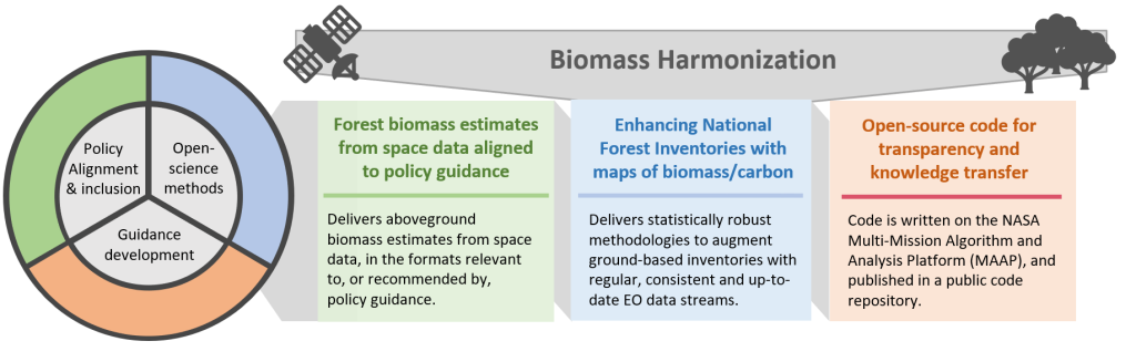
Biomass Harmonization is a coordinated effort of scientists to release forest-carbon estimates obtained with space data in a comparable manner. This helps identify underlying assumptions, definitions and uncertainty-estimation frameworks (Ref 1). By collaborating with scientists and policy-makers in various countries, this effort also aims to align the carbon estimates with policy guidelines, which will ease their uptake for climate reporting purposes. 

An example of this effort is research that leverages data from NASA’s GEDI and ICESat-2 missions, and ESA’s Climate Change Initiative (CCI) to produce IPCC Tier 1 default biomass values for natural forests (Ref 2). The integration of the various space-derived datasets is conducted within an open-science framework (Ref 3) aimed at enhancing the flexibility and adaptability of the estimates by countries. 

The CEOS Biomass Harmonization activity is funded by the NASA Carbon Monitoring Systems (CMS) 2022 and hosted on the NASA MAAP, where open science and a public repository of source code (Ref 4) permits transparency in a collaborative environment between science teams and national policy experts.

References: 

Ref 1 – https://iopscience.iop.org/article/10.1088/1748-9326/ad0b60

Ref 2 – https://authorea.com/users/747800/articles/720021-intergovernmental-panel-on-climate-change-ipcc-tier-1-forest-biomass-estimates-from-earth-observation

Ref 3 – https://daac.ornl.gov/CMS/guides/CMS_Global_Forest_Age.html

Ref 4 – The public Github Repository: https://github.com/CEOSBiomassHarmonization/NASA_CMS/tree/main/NASA_CMS_2023

Arctic-Boreal Vulnerability Experiment (ABoVE)

August 23, 2023

Mapping boreal forest biomass recovery rates across gradients of vegetation structure and environmental change.

The ABoVE boreal biomass mapping project has produced on MAAP a circa 2020 boreal-wide 30-m aboveground biomass map from ICESat-2 forest structure, Landsat, and other ancillary products (Ref 1). Collaborating across multiple institutions, aboveground biomass density models were created and fit to 19 million ICESat-2 observations (Ref 2), and boreal forest structure from spaceborne remote-sensing has been validated at multiple scales (Ref 3, Ref 4).

Now, the work is continuing: assessing changes in boreal biomass over time, starting with areas affected by wildfire (Ref 5), and using a suite of time-series data from Landsat and Sentinel-1 to expand to boreal-wide annual change and mapping of biomass recovery-rates after disturbance.

References:

  • Ref 1, Duncanson et al. 2023: https://doi.org/10.3334/ORNLDAAC/2186
  • Ref 2, Neuenschwander et al. 2024: https://doi.org/10.1016/j.srs.2024.100150
  • Ref 3, Feng et al 2023: https://doi.org/10.1016/j.rse.2023.113570
  • Ref 4, Neuenshwander et al. 2020: https://doi.org/10.1016/j.rse.2020.112110
  • Ref 5, Feng et al 2024, DOI: 10.1109/JSTARS.2024.3400218
  • « Go to Previous Page
  • Page 1
  • Page 2

NASA MAAP

MAAP is a collaboration between ESA and NASA

  • Privacy Policy
  • Accessibility
  • ESA MAAP