
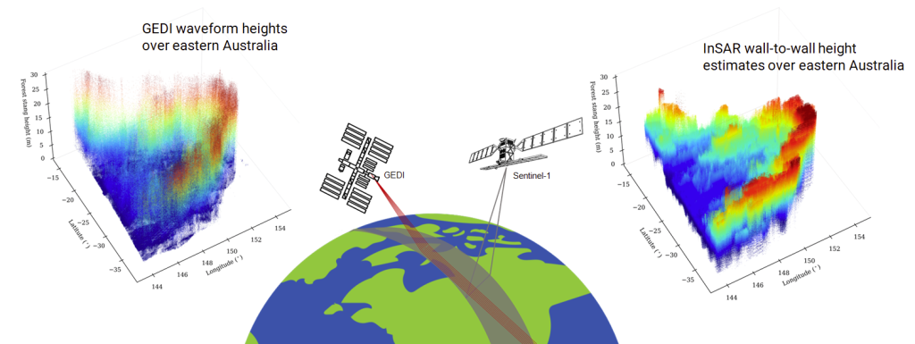
Dry forests and savannas have highly heterogeneous horizontal and vertical structure of woody vegetation and high temporal variability in moisture and phenology. This presents distinct challenges to SAR-based approaches to mapping canopy-height compared to tropical and temperate forests. Dense time-series of C-band (Sentinel-1A/1B) and, in future, L-band (NASA/ISRO NISAR) provide a pathway to reduce the impact of signal-noise and environmental conditions and to extract additional information more directly related to height, using repeat-pass Interferometric SAR (InSAR) techniques. This work explores the potential information in Sentinel-1(S1) C-band InSAR temporal decorrelation and Global Ecosystem Dynamics Investigation (GEDI)-derived relative height metrics for canopy height estimation. The 12-day InSAR correlation (𝛾) and seasonal median were analyzed over a wide range of canopy heights and woody ecosystems, with a focus on dry forests and savannas in Australia, India, and South Africa as part of a NASA Carbon Monitoring System (CMS) investigation. To scale up the geographical extent, the algorithm was deployed on NASA’s Multi-Mission Algorithm and Analysis Platform (MAAP). To further enhance the computational efficiency, a tile-based approach is employed using the Military Grid Reference System. The canopy height maps were produced for ~12.3 million km2 by processing nearly 1500 10x10 Sentinel-1 C-band Coherence tiles and approximately 130 million GEDI samples. In summary, this study provides new insights into the applicability and limitations of using InSAR data for canopy-height estimation in dry forest and savanna studies. Implementation of the proposed canopy-height estimation algorithm on the NASA-MAAP enables global scalability with current and future InSAR time series. The limitations with the C-band could be overcome partly, if not completely, with longer wavelengths like the L-band, such as those proposed for the upcoming NISAR, ALOS-3/PALSAR-4, and ROSE-L missions.
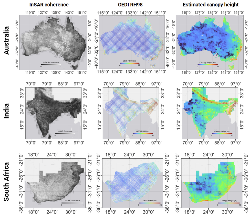
Figure 1. Maps of estimated canopy height for three countries using Sentinel-1 InSAR coherence and GEDI RH98.
Test site | No. of1ᵒ x 1ᵒtiles | No. of GEDI samples x106 | 100m | 500m | 1000m | |||
| r | RMSE | r | RMSE | r | RMSE | |||
| Australia | 910 | 68.3 | 0.75 | 3.74 | 0.85 | 2.56 | 0.89 | 2.05 |
| India | 408 | 52.1 | 0.66 | 5.18 | 0.83 | 3.49 | 0.88 | 2.71 |
| South Africa | 165 | 9.2 | 0.44 | 3.35 | 0.56 | 2.38 | 0.59 | 2.02 |
Narayanarao Bhogapurapu1 Paul Siqueira1, John Armston2, Mikhail Urbazaev2, Xiaoxuan Li3, Konrad Wessels3, Laura Duncanson2
1 University of Massachusetts Amherst,2 University of Maryland, 3 George Mason University
Related Publications:
- N. Bhogapurapu, P. Siqueira, J. Armston, Xiaoxuan Li, M. Urbazaev, K. Wessels, and L. Duncanson 2023 “Largescale forest stand height estimation using C-band InSAR correlation,” Geoscience and Remote Sensing Symposium(IGARSS), IEEE International.
- N. Bhogapurapu, P. Siqueira, J. Armston, Xiaoxuan Li, M. Urbazaev, K. Wessels, and L. Duncanson 2023 “Large-scale Canopy Height Estimation using C-band InSAR Correlation,” PolInSAR 2023: 11th International Workshop on Science and Applications of SAR Polarimetry and Polarimetric Interferometry and BIOMASS Workshop
- N. Bhogapurapu, P. Siqueira, J. Armston, Xiaoxuan Li, K. Wessels, L. Duncanson 2022 “Temporal analysis of C-band InSAR decorrelation for canopy height mapping over dry forests and tropical savannas “, AGU Fall Meeting 2022.